


The Shortcut to Knife Rock
By Isaiah Winters
Few natural landscapes in Honam inspire me enough to visit twice in a single week, but Boseong County certainly boasts one. Located about an hour and change southeast of Gwangju, Obong-san (literally “five-peak mountain”) has left me smitten for its topographical variety, bucolic bayside views, and one of the most unique rock formations I’ve ever seen: Knife Rock (칼바위). In this edition of “Lost,” I’ll carve out a few paragraphs on what puts this mountain in my top 10.
Gradually Then Suddenly
The main ridge to Obong-san’s 343-meter summit forms a left-facing crescent, with the upper half progressing along a low, gradual incline and the lower half jutting up and down along the mountain’s steep, rocky peaks. Thinking the gentle upper trail would make it easier for the missus, we parked by an abandoned hanok near Deukryangnam Elementary School (득량남 초등학교) with the idea to saunter the entire crescent and back on easy mode. But by the time we got to Knife Rock, which isn’t even the main peak, we realized we’d greatly underestimated the time and length of the trek and so had to cut it short. On our detour back to the elementary school, we descended into the valley beneath Knife Rock and took the boardwalk overlooking the pristine reservoir below.
It was here that we realized we could have just parked by the reservoir, had a short hike up to the best parts of the mountain, and then returned in style. Walking back through the valley’s broad grass fields and scattered cattle farms, we had plenty of time to ruminate on our mistake. So, for anyone thinking to hike the entire crescent and then return through the valley, my advice is to set aside five or six hours for the whole thing and be sure not to bring along shutterbugs who cause delays or anyone who’s prone to gradual (and then sudden) pangs of debilitating hunger. We had one of each between the two of us – enough said.
On my second visit a few days later, I was sure to park as close to the summit as possible just above the reservoir. If you want a huge payoff with the least amount of time and effort, this is the way to go, especially if you’re prone to wasting a lot of time fiddling with cameras. I was able to get my shots and sound recordings all around Knife Rock and then return to the car in under two hours. This gave me time to enjoy the gentle twists and turns of Highway 29 as I drove back to Gwangju through Hwasun – that is, until the rush-hour bottleneck between the two cities triggered an abrasive return to reality. Such is life.
Views All Around
Though admittedly long, one major benefit of taking the gradual trail from the elementary school is the series of stunning views east. As we hiked southeast towards the bay, we got a better and better view of the grasslands in the floodplain below, in addition to an earful of local villagers wailing to trot music over loudspeakers. Though their singing was a bit tone deaf and cranked up to 11, we were happy they could blow off some steam in a healthy way, just like us. When not singing their hearts out, the local farmers tend to their vast grassland grids spread out across the coastal area below, where a few streams flow into Boseong Bay.
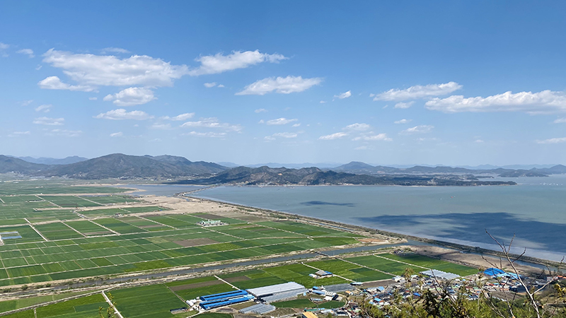
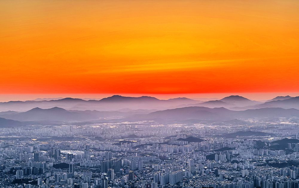
Boseong Bay is the massive stretch of water separating most of Goheung County to the east from Boseong and Jangheung Counties to the west. If you’ve ever been to Yulpo Beach, that’s the area I’m referring to. From the ridge, the view out over Goheung Peninsula is stunning and provided us a great vantage point to see all the beaches we dreamed of buying land at a year ago. We’d always seen the bay from the Goheung side, so seeing things from the flipside was fun and brought back lots of memories of the naïve old days when we planned to buy a second home in Goheung before buying a first home anywhere else. Slowly realizing that order made no sense was another firm smack of reality. But I digress.
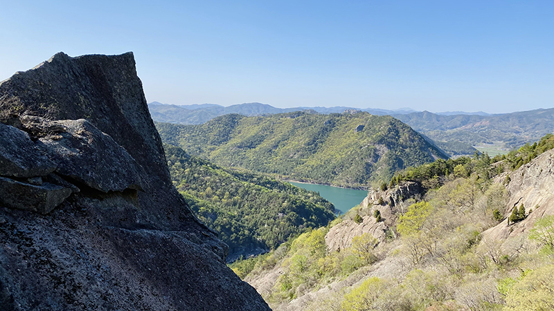
Obong-san offers many other impressive views both near and afar. We were able to see beyond the narrow stretch of land connecting Goheung to the mainland all the way to the Yeosu Peninsula. Turn around and you’re treated to the surprisingly bright-blue waters of the reservoir down in the valley below. At various points along the way, massive stupas meticulously made of slate fragments guide you along the ridge as you draw ever nearer to the mountain’s main attraction: Knife Rock.
The Blade of Boseong
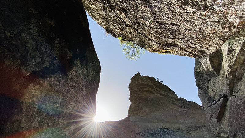
Though it only tops out at 310 meters, the Knife Rock formation is simply amazing to behold. There are numerous vantage points from which to view it, and from each angle, it looks like something different. From a distance, it looks a bit like Half Dome at California’s Yosemite National Park, only with a far sharper and more prominent hood extending out over the rockface. Some compare it to a bird’s beak or even a toad, while to me, at least from the bottom looking up, it resembles a surfer’s-eye view of a cresting wave. The fact that it’s quite asymmetrical gives it an eerily precarious look unlike anything else I’ve seen.
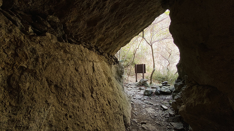
There’s a lot more to this natural marvel than just its shape. It also comes with a series of tunnels, caves, and deep crevices that you can explore at your own risk. So, feel free to jump down and spelunk its many voids; just let someone know where to find your corpse beforehand. For a safer experience, at the entrance to Knife Rock, a large, angular tunnel guides you right to the foot of the formation, where a park signboard explains the rock’s significance. If you look up from there and squint a bit, you can just make out a stone carving at the base of the rock’s hood that must have been terrifying to sculpt. There’s debate about whether it depicts Buddha or Wonhyo, on of Korea’s greatest Buddhist thinkers. The way I see it, the carving was such a hazardous feat that whoever did it should have just made a self-portrait. What a legend.
One other detail about Knife Rock that makes it worth visiting is that it offers many shaded areas and dark caverns to cool down in after a sweaty hike. For a summer daytrip, I imagine this hike would pair nicely with a swim at Yulpo Beach, just a 25-minute drive away. Anyway, enough salesmanship on my part. Just go visit, or if you want to see it in detail first before deciding, check the Lost in Honam YouTube channel for more.
The Author
Hailing from Chino, California, Isaiah Winters is a pixel-stained wretch who loves writing about Gwangju and Honam, warts and all. He’s grateful to have written for the Gwangju News all these years. More of his unique finds can be seen on Instagram @d.p.r.kwangju and YouTube at Lost in Honam.