The End of Jaeun-do
By Isaiah Winters
Last month’s edition of “Lost” had us feeling our way along a dark coastal cave at the southernmost tip of Imja-do. This month, we’ll trek to the extreme western edge of Jaeun-do, another of Sinan-gun’s many superb but under-visited islands. Jaeun-do has at least a half dozen sites and experiences of note I could talk about: the large, abandoned school complex that haunts the landscape, what Mariposa Resort was like back when I found it a burned-out derelict, the excellent hike to the peak of Dubong-san, dodging bats at the island’s decommissioned military site, discovering one-of-a-kind temple ruins amid a forest of bamboo, and two vast beaches that merge into an epic promontory scarcely anyone visits. For this article, we’ll focus just on the temple ruins and beach promontory.
Wait, Where Is Jaeun-do Anyway?
In Sinan-gun, if you take the colossal “Angel Bridge” from Aphae-do to Amtae-do, you’ll end up at a well-known fork in the road featuring a lifelike painting of a welcoming elderly couple whose bushy hair blends with the trees behind them. Hang a right at the fork and you’ll be on your way to our destination: Jaeun-do. You’ll know you’ve arrived once you cross a second bridge and see an even more detailed painting, this time of an elderly, bushy-haired trio, though with the intended trees oddly missing from the background. Not long after this, you’ll see the abandoned school complex mentioned earlier. Hang a left there and you’ll reach the Jaeun-eup Office located smack in the middle of the island. From there, you can go any number of directions.

Bamboo Forest Temple Ruins
If I had to rank my most unique finds across all of Honam, the temple ruins on Jaeun-do would definitely be among the top five. The first reason why is for the absurd luck I had in finding it, as it’s not listed online, it’s nowhere near anything of note, and even if you do get close by, you can’t really see it. Dumb luck and a bad sense of direction sometimes deliver, however. It was only after I misread my map and went off course that I discovered this one-of-a-kind derelict, which is how a lot of my luck works: like the way lost-and-found items are always somehow together in the same place. Anyway, serendipity alone isn’t enough to warrant a top-five ranking, so there’s a lot more to this find than its elusive coordinates.
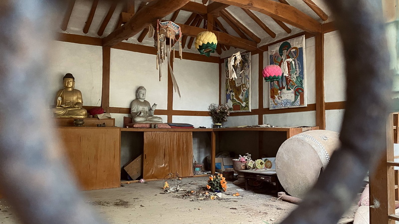
The second reason why these ruins rank so high is due to their level of preservation. Though the floorboards are weak and badly warped by the island’s constant humidity, the walls, pillars, and roof still seem very sturdy. The thick forest surrounding the main building has protected it from decades of strong, onshore winds and even stronger typhoons. Though part of the roof in two areas was smashed open years ago, likely by fallen trees, most of the nearby vegetation is bamboo, which grows tall but doesn’t fall nearly as hard – perfect for wind protection without causing major damage. Another testament to the temple’s fortuitous placement is that bats like to take shelter in it, which was an unpleasant surprise the last time I visited. One flapped silently by my wife, who quickly turned around and asked, “What was that?!” I knew what it was but feigned ignorance to save her from a heart attack. When another bat flapped by my head a few minutes later, we noped right on out of there.

In addition to the temple ruins being an exceptionally lucky and well-preserved find, the many religious artifacts still inside help solidify it among my top-five unique discoveries. The main building still has four Buddhist statues, only one of which is smashed, a few hanging paper lanterns, and a pair of traditional drums. One is a busted janggu (장구) still with its connective ropes but missing its hourglass-shaped midsection, and the other is a large, barrel-like buk (북) that’s valiantly resisting the elements despite being closest to the temple’s worst-damaged corner. The walls are also still adorned with two colorful paintings of a hoary, Gandalf-looking man known as “the mountain spirit.” In one picture, a tiger looks to be protecting him beneath a tree, while in the other he stands upon clouds with two dragons seemingly at his beck and call, or something. I think they represent “something, something spiritual – something, something enlightenment.” (I really wish I were more knowledgeable about these things.)
Anyway, these temple ruins are one of Jaeun-do’s hidden gems that I bring only close friends to see. As of now, nothing is being done with the property, and it looks to have been entirely forgotten by its owner, making me its only regular steward in a way. My friend and hanok restorer Kang Dong-su, upon seeing my first photos of the site, wrote, “Looks like it was built in the 1960s–1970s. Hope it can meet a good owner again.” I hope so, too.
Hiking to the Windswept, Western End of Jaeun-do
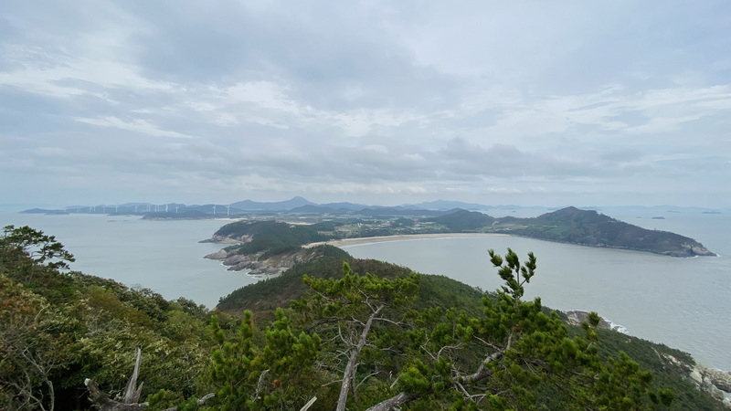
The further west you go along Jaeun-do, the more the island tapers to a point, sort of like a left-facing arrow. Along the upper portion of that arrow, the broad shore of Yangsan Beach slopes down to meet Bungye Beach, the lower portion of the arrow tip. However, right where the two beaches should meet, a rocky bluff stabs up between them before attenuating further into an incredibly narrow peninsula. Follow that peninsula as far as you can go and you end up at the peak of Eungam-san, the windswept, western end of Jaeun-do. (I’d like to emphasize windswept.) We went during a particularly odd weather formation where cool, norther winds from Manchuria clashed right over Korea with warm air rising from the Pacific. Together that made for gloomy, typhoon-like skies and non-stop gusts of uncomfortably humid wind. We were soaked with sweat by the end.

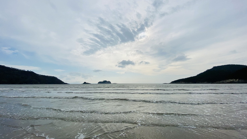
Nevertheless, the summit views from Eungam-san were very rewarding. Look west and you have a perfectly unobstructed view of the vast Yellow Sea with scarcely an island in sight. It’s as if Korea completely stops there. To the south you see a few islands off the opposite bluff hemming in the southern side of Bungye Beach, which sits nestled between the two verdant promontories. The view east is arguably the best, as it guides your eye back along the long, winding peninsula you just traversed and then diverts left and right along the arrow tip’s two beaches. Unfortunately, views to the north are largely blocked by trees, but three directions out of four isn’t bad. After a few moments soaking it all in, we headed back down to get some dinner.
One of the best things about this coastal hiking trail is that it conveniently begins and ends at the beach, so when the weather is warm enough, you can cool down in the water after the hike’s over. We didn’t have the time or gear for an additional beach excursion, so we just enjoyed walking along the long, sandy stretches of Bungye Beach until we got to the big seafood restaurant near the parking lot. You can’t miss it. Our dinner of grilled fish coupled with views of the sunset-lit beach was Honam at its best. As an interesting aside, when we went to pay our bill, the owner seemed a bit concerned upon seeing my camera and asked us if everything was to our liking. Apparently, a YouTuber had visited the restaurant and given them an unflattering review, which was a little sad to hear given the quality of the meal we’d just had. Anyway, we think the place is worth a visit.
By the way, if you want to see me try my hand at a new medium, I’ve made a video version of this article called “The End of Jaeun Island” over on my small, new-ish “Lost in Honam” YouTube channel. There are also other videos on the channel that mirror a few of my Gwangju News articles, like last issue’s coastal cave expedition on Imja-do. Besides these, there are videos of other abandoned, historical, and natural finds across Honam that I think are interesting. I hope you enjoy them, too.
The Author
Born and raised in Chino, California, Isaiah Winters is a pixel-stained wretch who loves writing about Gwangju and Honam, warts and all. You can see some of his unique finds on Instagram @d.p.r.kwangju and YouTube at Lost in Honam.


