

The Mountain We Are Wearing Down
By Siddhant K. ||
For many of us in Gwangju, Mudeung Mountain is not a destination so much as a habit. It is a green curtain at the end of the bus line, the ridge that turns gold in late October, the place a first-time visitor is taken almost as a rite of welcome. Few big cities anywhere sit this close to a national park; you can leave an apartment in Dong-gu and be walking under old pines within the hour. That intimacy is the mountain’s gift and, increasingly, its burden.
Mudeung Mountain became South Korea’s twenty-first national park in 2012, and in 2018 the wider area was recognised as a UNESCO Global Geopark, prized for its vast columnar-joint rock formations, Seoseok-dae, Ipseok-dae, and Gwangseok-dae, that fan out near the summit. Protection on paper, however, does not lift a single boot off the trail. The same closeness that makes the mountain so easy to love is what steadily grinds its footpaths down.
A Mountain Loved by the Millions
Put simply, a great many feet pass this way. National figures put Mudeung Mountain among the busiest mountain parks in the country; by one widely cited count, roughly 3.5 million visits in a single year, placing it behind only Bukhan Mountain and Seorak Mountain. Bukhan and Seorak, though, are buffered by distance and size. Mudeung Mountain is an urban mountain: hemmed by a metropolitan area of well over a million people, reachable by ordinary city bus, and busiest on exactly the crisp autumn weekends when its slopes are least able to shrug off the traffic.
Visitor pressure is not spread evenly, either. It funnels. The Jeungsim Temple entrance on the Gwangju side draws the heaviest crowds, while quieter approaches through the Wonhyo Valley and around Gyubong Hermitage keep more of their wild character. Where people concentrate – at viewpoints, on the steep pitches up to the colonnades, at the natural bottlenecks where everyone pauses for the same photograph – the ground takes the strain. And ground, unlike a schedule, does not recover between weekends.
How a Trail Actually Wears Out
Erosion on a mountain path is rarely a single dramatic event. It is thousands of small, ordinary steps. Researchers who compared a heavily used stretch of Mudeung Mountain trail with a lightly used one found the busy path measurably wider, its surface soil packed hard. Trampling raises the soil’s density and resistance, while squeezing out the fine particles and moisture that let roots breathe and rain soak in. Compacted earth cannot absorb water, so rain runs across the surface instead of sinking, and running water is a patient sculptor.
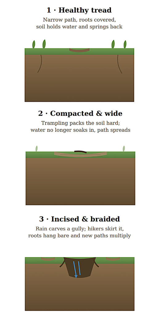
How a footpath wears down. Cross-section through a hill-side trail, from healthy tread to eroded scar.
From there the sequence is familiar to anyone who hikes here often. A packed path sheds water, the water carves a shallow channel, and the channel deepens into a rut studded with tripping stones and bare, exposed roots. Walkers step around the rut to keep their footing, trampling the vegetation at the edges, and the path quietly
widens or splits into braids. Each rainy season the scar is a little deeper and a little broader. On steeper sections, gravity does the rest.
This is why a worn trail is not merely an eyesore. Exposed roots injure the trees that anchor the slope. Widening paths nibble into habitat. And in a place built on prized rock and thin mountain soil, lost ground is not easily put back.
The Summit Question
Nowhere is the tension between protection and access sharper than at the top. Mudeung Mountain’s highest peak, Cheonwang-bong (1,187 m), has been off-limits to the public for decades: Military facilities were installed on the summit’s peaks in 1966, and the crown of the mountain effectively disappeared behind a fence. For a generation, the busiest mountain in the region kept its own summit closed.
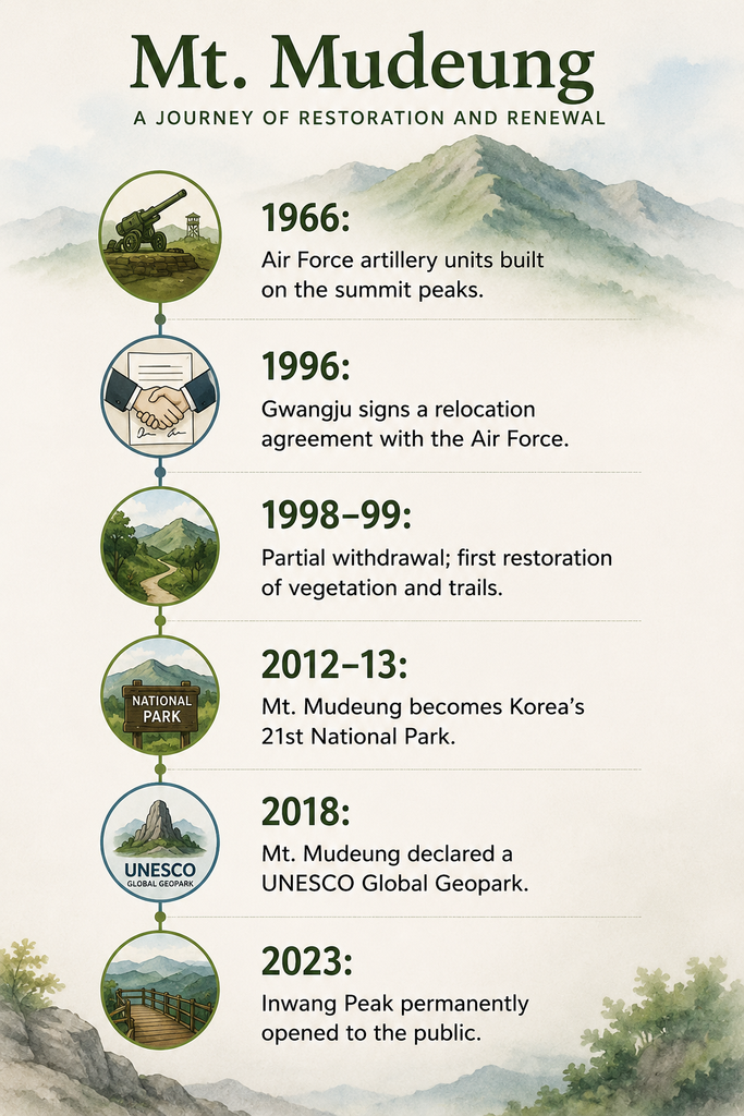
(GN with ChatGPT)
The slow reversal of that arrangement is one of the defining conservation stories of the area. Gwangju signed a relocation agreement with the Air Force in 1996; a partial withdrawal in the late 1990s allowed the first restoration of vegetation and trails on ground the military had held. In September 2023, one of the summit peaks, Inwang-bong, was opened to the public permanently. Full public access to Cheonwang-bong itself is tied to the base’s eventual relocation, a milestone often discussed to occur around the end of this decade.
The paradox is worth sitting with. The very fence that kept people out also kept the summit’s ecology largely undisturbed for half a century. As access opens, the mountain gains back its peak but takes on precisely the pressure that has worn its lower trails. Reopening, in other words, is not the end of the conservation problem, it is the start of a new one.
Managing Access Without Locking the Gate
The park’s answer is not to choose bluntly between conservation and access, but to ration and steer access so the mountain can keep up. Several tools are already in use, and international residents will meet them directly.
- Reservations for the summit. Because the top sits within a military zone, the summit-area trails run on a booking system with identity checks, along short, set routes. If you intend to stand near the roof of the mountain, check and reserve through the Korea National Park Service before you go, and carry ID.
- Seasonal closures. Sections of trail close during the spring and autumn wildfire-risk periods and after heavy rain. These are not bureaucratic whims; they let battered ground rest exactly when it is most fragile. A closed gate is cheaper than a decade of restoration.
- Hardening and rerouting. Where footfall cannot be reduced, it is absorbed, with steps, stone paving, drainage, and boardwalk on the worst-hit pitches, and with older, tired trails rebuilt to shed water rather than channel it. The restored Mudeung Mountain Old Path (Yet-gil), reopened in 2011 along a historic route to Seoseok-dae, is also a gentler, more ecologically intact way up for those willing to trade a little speed for a lot of quiet.
- Education through the Geopark. Geopark and eco-center programs, guided geology walks, and visitor centers at the main trailheads all nudge behavior in the same direction, keeping people on the tread and off the fragile verges.
Walking It Lightly
None of this argues for staying home. Mudeung Mountain is meant to be walked, and a mountain that people know is a mountain that people defend; the grassroots movements that pushed to reclaim the summit grew from exactly that affection. The aim is to let it carry us for another few generations. A handful of habits go a long way:
- Stay on the marked tread, even when it is muddy or rutted, stepping around the puddle is how paths widen.
- Spread out in time and space: Go early, go midweek, or choose the Wonhyo or Gyubong Hermitage approaches over the crush at Jeungsim Temple.
- Respect the closures and the reservation rules rather than reading them as obstacles.
- Carry out everything you carry in; the mountain has no cleaning crew above the tree line.
The question facing Mudeung Mountain is not really conservation versus access. It is how to keep offering the second without diminishing the first. So far, the mountain has answered generously, one bus ride, one golden ridge, one open peak at a time. The least we can do on the way up is tread as though we mean to come back.
The Author
Siddhant K. is a geochemical ocean-ographer and researcher at TMBL at the Gwangju Institute of Science and Technology (GIST). His work focuses on marine minerals, sediment chemistry, and paleoenvironmental change. He is passionate about communicating ocean science to broader communities in Korea.
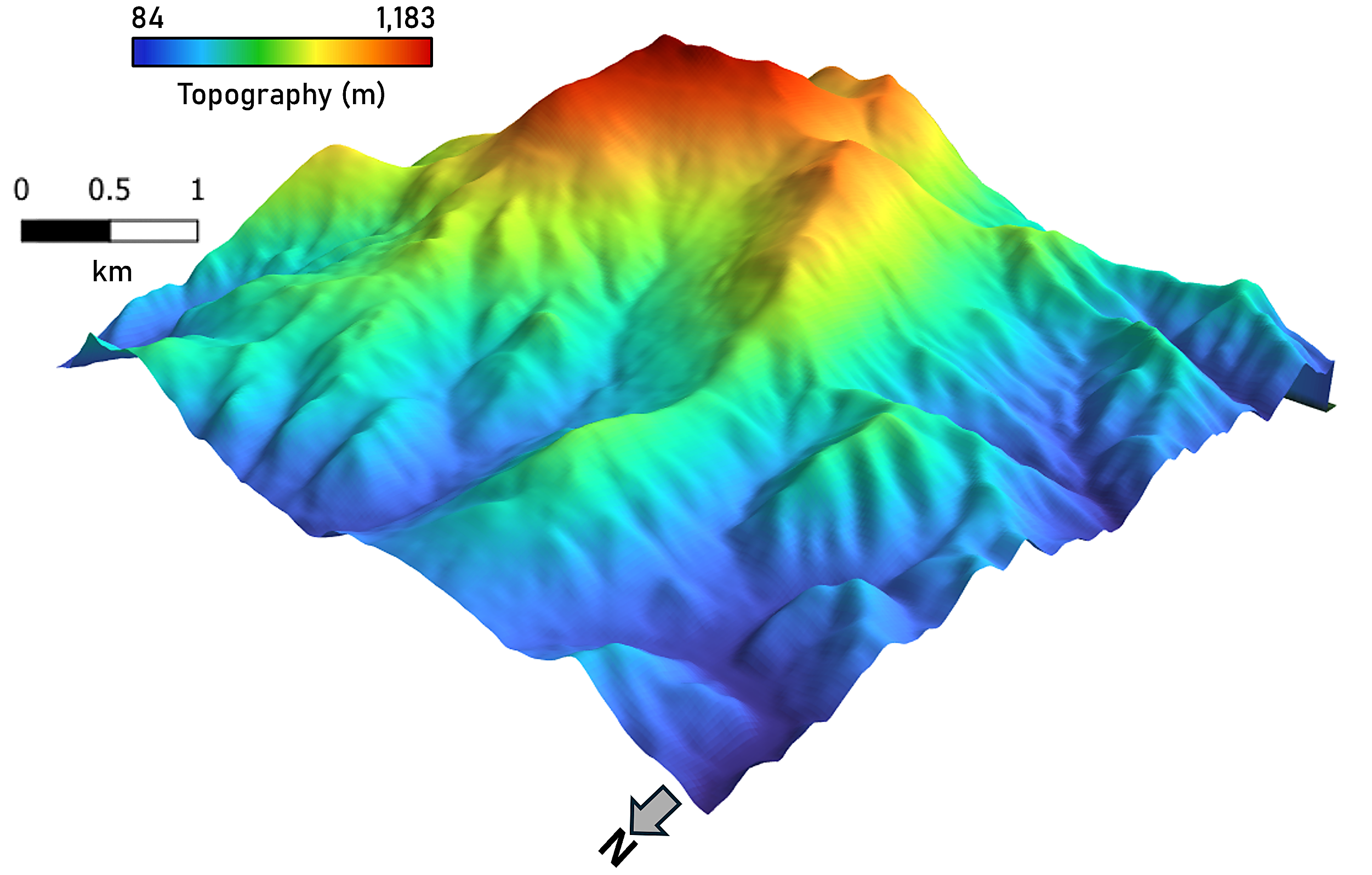
Cover Photo: Topography of the summit of Mudeung Mountain.