

The Yeongsan River: Flowing Under One Government
By Siddhant K. ||
For the first time, almost the entire Yeongsan basin, from its source in Damyang to the estuary near Mokpo, sits inside a single administration. That alignment could reshape how the region cleans, plans, and protects its defining river.
On July 1 of this year, Gwangju Metropolitan City and Jeonnam Province (Jeollanam-do) stopped existing as separate governments. They became Jeonnam-Gwangju Special Metropolitan City, a single provincial-level administration of roughly 3.2 million people, reuniting a city and a province that had been run separately since 1986. Most of the attention has gone to semiconductors, jobs, and whether young people will now build their lives here rather than in Seoul. But the merger also did something quieter that the region has never pulled off before: it placed nearly the whole Yeongsan River under one jurisdiction. For a river that has spent decades being managed in pieces, that is not a small thing.
One River, Two Old Borders
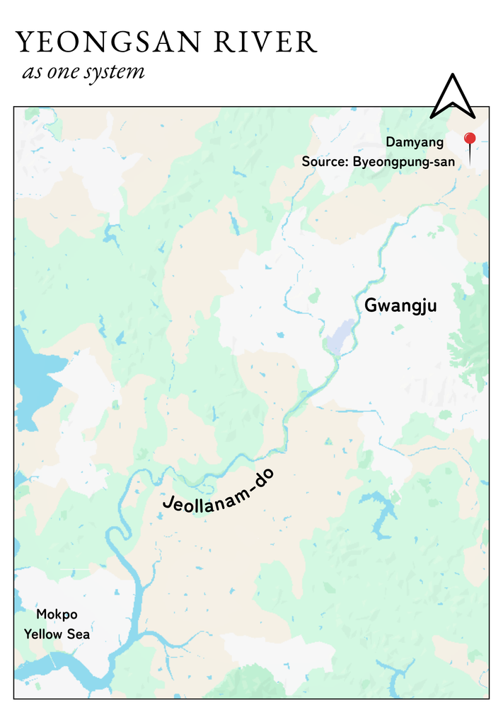
The Yeongsan River rises on Byeongpung Mountain in Damyang, runs about 129.5 kilometers southwest through Gwangju, past Naju and across the lower plain, and drains into the Yellow Sea beyond the estuary bank near Yeongam and Mokpo, which was built in 1981. Its basin covers roughly 3,468 square kilometers, the smallest of Korea’s four major rivers, but it’s the water supply and the rice bowl for the entire southwest.
(GN with Canva)
Trace the channel, and you used to cross the old administrative line not once but twice. The headwaters sat in Jeollanam-do; the middle reach, including the Gwangju urban core and the Seungchon Weir, sat inside Gwangju city limits; then the river passed back into Jeollanam-do for Naju, the estuary, and the sea. One continuous body of water, three separate segments of authority. Since July, all of it answers to the same government.
Why the Old Map Made the River Hard to Clean
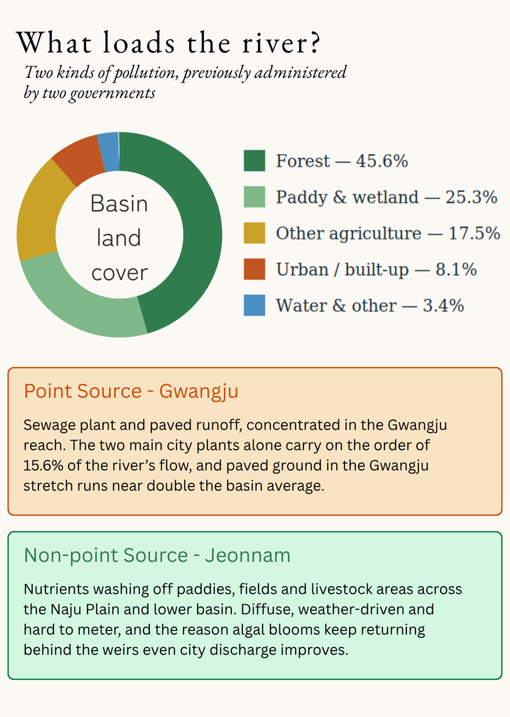
A river collects two very different kinds of pollution, and the old boundary happened to split them almost perfectly. The point sources of sewage plants and runoff from paved ground were concentrated in the Gwangju reach. The city’s two main treatment plants alone are estimated to carry on the order of 15.6% of the river’s flow, and paved, water-shedding ground in the Gwangju stretch runs close to double the basin average. That was Gwangju’s to manage.
The non-point sources of nutrients washing off of paddies, fields, and livestock areas across the Naju Plain were spread thinly across the countryside, diffuse and weather-driven. That was Jeollanam-do’s. The result is the recurring summer problem the region knows well: algal blooms that pool behind the weirs and turn stretches of the river green. Improving city discharge alone never fixed it because the nutrients feeding the blooms were arriving from farmland under a different government’s remit.
(GN with Canva)
Who Actually Pulls the Levers
Integration reshapes the local tier, but it leaves the national one untouched, and that distinction matters. Water-quality standards and discharge permits still come from the Ministry of Climate, Energy, and Environment, the renamed and enlarged national environment ministry. Day-to-day basin monitoring and enforcement still run through the Yeongsan River Basin Environmental Office in Gwangju. And the largest single decisions about the river’s structure sit with the basin and national water-management committees, not with city hall.
What did change is the local seam. Where there were two governments, each with its own priorities, its own budget cycle and no single owner of the whole river, there is now one. Urban wastewater and farm runoff finally sit under the same roof; land-use planning can, in principle, run from the headwaters to the estuary, and the region speaks to Sejong with one voice instead of two.
The Weirs: The Clearest Test
Nothing shows the limits of local power more sharply than the Seungchon and Juksan weirs. Built on the main channel in 2011–2012 under the Four Major Rivers Project. The Seungchon Weir in Nam-gu, Gwangju, and the Juksan Weir in Naju have slowed the river, lengthened its retention time, and been linked to the persistent algal blooms ever since.
Their fate has swung with national politics. A plan to dismantle Juksan and permanently open Seungchon was finalized by the national water authority in early 2021, then cancelled in 2023, and as of early 2026, the government was once again reviewing whether to keep the weirs for water supply and flood control. The point for readers is this: Even a unified regional government cannot simply decide the weirs’ future on its own. What it can now do is arrive at that national table as the single, coherent voice of the entire basin – upstream city and downstream farmland together – rather than as two governments that did not always agree.
What One Government Could Actually Do
The promise of integration is alignment. A single administration can, at least on paper, write one basin plan instead of two that stop at a shared border; direct a single budget to wherever on the river can best be used; and coordinate the sewage upgrades of the former city with the farm-runoff measures of the former province so that the two finally pull in the same direction.
The reach extends past water quality. The same government now oversees the estuary and coast where the river meets the sea, the tidal wetlands of the lower basin, and Jeonnam’s fast-growing offshore-wind and energy plans – all of which interact with the health of the Yeongsan. A regional climate and water strategy that treats the basin as one connected system, from Damyang’s reservoirs to the Yeongam estuary, is now an administrative possibility rather than a diplomatic negotiation between two capitals.
What the Merger Will Not Fix by Itself
It is worth being sober. Redrawing the map does not automatically merge the pipes, the farm subsidies, the monitoring datasets, or the staff who ran two systems for forty years. The major source of pollution – diffuse agricultural runoff – remains major, whoever is in charge. The biggest structural lever, the weirs, stays with the national tier. And beneath the new special city, districts and county-level functions continue, so “one government” is really one strengthened coordinating layer, not a single desk. Integration removes an excuse and creates an opportunity. Whether the river actually gets cleaner depends on what the new administration chooses to do with both.
For Residents: What to Watch
For international residents who walk, cycle, or run the Yeongsan River path, three things are worth following over the next year. First, whether the new city publishes a single, basin-wide water or environment plan, and whether it names the Naju Plain’s farm runoff, not just city sewage, as a target. Second, the weir decision, which will be made nationally but shapes the water you see. Third, summer algal-bloom advisories, which the Yeongsan River Basin Environmental Office continues to issue, and which are the most immediate, practical guide to when and where to keep pets and children away from the water’s edge. Forty years after Gwangju and Jeollanam-do were separated administratively, the river that was always shared is now, on paper, whole again. The next few years will show whether the government that inherited it treats it that way.
The Author
Siddhant K. is a geochemical ocean-ographer and researcher at TMBL at the Gwangju Institute of Science and Technology (GIST). His work focuses on marine minerals, sediment chemistry, and paleoenvironmental change. He is passionate about communicating ocean science to broader communities in Korea.
1 CC BY 2.0, https://commons.wikimedia.org/w/index.php?curid=7518579
Cover Photo: The Yeongsan River flowing through Damyang. (By Byungjoon Kim – IMG_1144 ¹)