


When the Sea Rewrites the Season
By Siddhant K. ||
Snow in April, cherry blossoms that will not come, Korea’s winter is no longer what it was, and the answers lie as much beneath the surface as above it.
In April 2025, residents of Seoul watched snow fall on streets that should, by every climatic expectation, have already been warm for three weeks. The cherry blossoms, for which the city plans festivals, arranges tourism infrastructure, and mobilizes an entire economic ecosystem, arrived late or not at all in many locations, disrupted by a cold snap that persisted well beyond what any historical average would suggest. For the casual observer, it was a curiosity. For those of us who read the sea, it was a data point in a story that has been accumulating for decades.
Korea sits at a remarkable meteorological crossroads. To its west lies the relatively shallow Yellow Sea; to its east, the East Sea (known internationally as the Sea of Japan), a semi-enclosed marginal sea of the northwestern Pacific whose thermal behavior has profound and underappreciated consequences for what happens on the peninsula’s surface. To understand why Korean winters have become increasingly erratic, delivering, in the same season, record snowfalls in November, deep cold spells in February, and anomalous April frosts, one must begin not with the atmosphere, but with the water.
A Sea Warming Faster Than the World
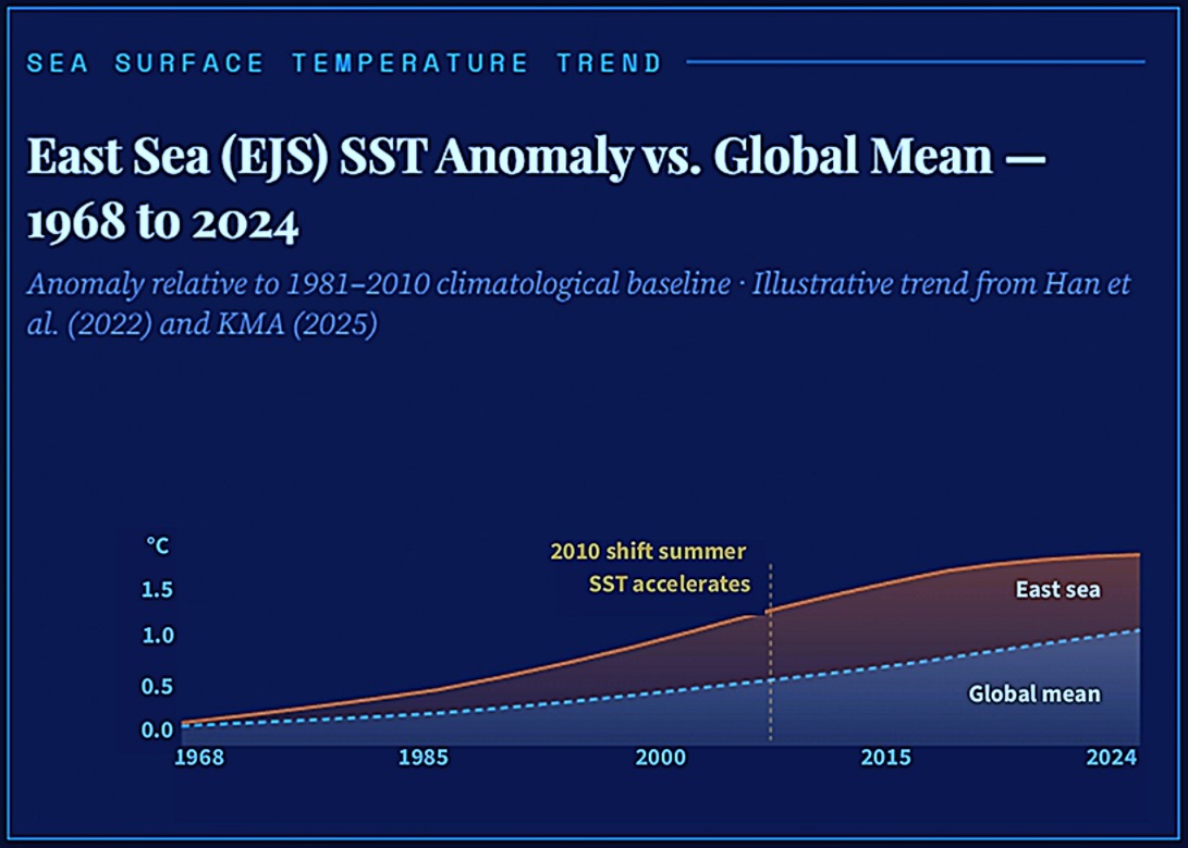
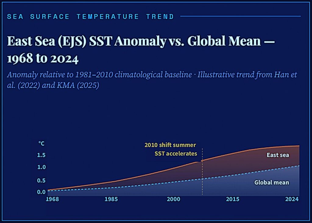
The East Sea is, by any oceanographic measure, a hotspot. Long-term satellite records show that annual mean sea surface temperature (SST) in Korean waters has risen at roughly 2.6 times the global mean rate over the past 55 years (1968–2022), a figure that ought to command far more public attention than it currently does (Han et al., 2022). For most of that period, the dominant warming signal came from the winter season: Cold-season SST rose quickly, moderating the thermal gradient between sea and land, and lending Korean winters a progressively milder character. This pattern, however, underwent a significant structural shift after approximately 2010.
Since the 2010s, the summer SST warming rate has outpaced winter warming by a factor of nearly four, driven by an intensified Tsushima Warm Current in the summer months and changes in the large-scale atmospheric forcing over East Asia (Han et al., 2022). What this asymmetry produces is not simply “warmer all the time”; it produces a system under tension, in which summer marine heat extremes set conditions that then collide, in winter, with a cold-air delivery mechanism that has itself been reorganized by Arctic processes.
The Arctic Connection: When Polar Vortex Speaks to Korean Winter
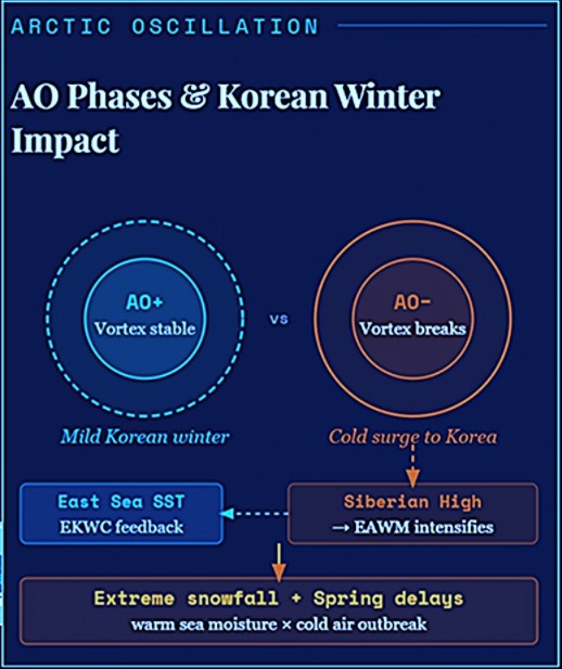
The atmospheric driver most responsible for the erratic cold episodes Korea has experienced in recent winters is the Arctic Oscillation (AO), and its relationship to Korean weather is mediated, crucially, through the ocean. The AO describes the dominant mode of variability in Arctic atmospheric pressure: In its positive phase, the polar vortex is strong and contained, cold air stays locked over the Arctic, and East Asian winters tend toward mild. In its negative phase, the vortex weakens, cold air drains southward through Siberia, and the East Asian winter monsoon (EAWM) intensifies.
What makes this system particularly pertinent to Korean oceanography is how the AO modulates SST in the East Sea itself. Research using high-resolution satellite and reanalysis products has shown that AO-related wind forcing drives SST variability in the northwestern East Sea through oceanic dynamic adjustment, specifically, through anomalous anticyclonic eddy-like circulation and Ekman downwelling during positive AO phases, and the reverse during negative phases (Song et al., 2023). The East Korea Warm Current (EKWC), which flows northward along the Korean eastern coastline as a western boundary current, responds measurably to AO forcing, with its strength index showing a statistically significant intensifying trend of approximately 0.62 cm per second every decade (Song et al., 2023).
The practical implication is this: Arctic variability does not reach Korea only through the atmosphere. It reaches Korea through the ocean, which then feeds back into atmospheric thermal patterns over the peninsula. The AO modulates the EKWC, which modulates coastal SST, which modulates air–sea heat flux along Korea’s eastern seaboard, a chain of causation that conventional meteorological framing tends to overlook.
The Siberian High and the Warming Sea: A Paradox
One of the more counterintuitive findings of recent Korean climate research is the re-strengthening of the Siberian High and the EAWM after a prolonged period of weakening. For much of the late twentieth century, the Siberian High was declining in intensity, consistent with a general warming of the mid-latitude land masses. But from the early-to-mid 2000s onward, this trend reversed: The Siberian High and EAWM shifted from a sharply decreasing trend to an increasing or neutral one, with winter wind speeds around Korea following suit (Han et al., 2022). The mechanism most invoked to explain this paradox is Arctic amplification.
As the Arctic warms disproportionately, and it is warming at two to four times the global mean rate, a phenomenon now well-documented, the temperature gradient between the pole and the mid-latitudes diminishes. A reduced pole-to-equator gradient weakens the jet stream, making it more susceptible to large-amplitude meanders.
These Rossby wave excursions allow cold Arctic air to plunge southward in certain sectors, even as the overall hemispheric mean temperature continues to rise. For East Asia, the relevant delivery mechanism is the continental cold air that forms over Siberia and descends through the EAWM pathway onto the Korean Peninsula.
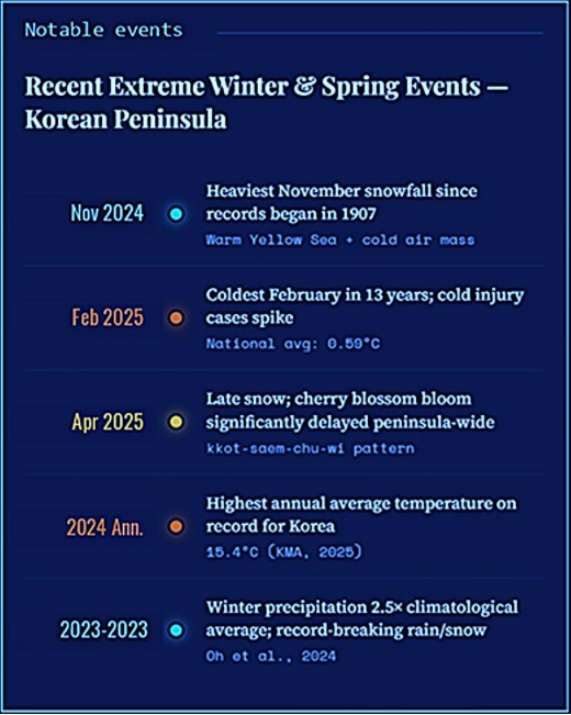
This is precisely the mechanism that produced the anomalous February 2025 cold spells documented by Korean health surveillance data, the lowest February temperatures recorded in 13 years, at a national average of 0.59°C, following an influx of a North Atlantic cyclonic storm into the Arctic that displaced cold air southward (KDCA, 2025). It is also what produced the remarkable November 2024 snowstorm: Seoul’s heaviest November snowfall since record-keeping began in 1907, driven by an unusually large temperature differential between cold air masses and the anomalously warm Yellow Sea surface (KMA, 2024).
The Yellow Sea Effect: Warm Water, Cold Air, Extreme Snow
The November 2024 event deserves specific attention because it illustrates the oceanic amplification mechanism with unusual clarity. The Korea Meteorological Administration attributed the unprecedented snowfall not simply to cold air from the northwest, but to the interaction of that cold air with a Yellow Sea surface temperature that was warmer than normal for the time of year. When frigid continental air masses traverse a relatively warm sea surface, the temperature and moisture contrast drives intense convective snowfall, a process oceanographers recognize as air–sea heat flux anomaly in action. The warmer the sea relative to the overlying air, the more vigorous the moisture transfer, and the heavier the resulting snowfall when that air reaches the cold land surface.
This mechanism is not new; it is the same physics that produces lake-effect snow in the Great Lakes region of North America. What is new is the frequency and intensity with which it is occurring in Korean waters, as background SSTs
rise and create more energetic contrasts with cold air outbreaks that are themselves increasingly abrupt due to polar vortex disruption. The interaction between a warming ocean and an increasingly variable atmosphere is producing a system of greater extremes at both ends of the thermal spectrum.
What the Cherry Blossoms Are Telling Us
Cherry blossoms are, in an unlikely sense, a phenological instrument; their bloom date integrates accumulated heat units in late winter and early spring, making them a proxy for the thermal history of the preceding weeks. The kkot-saem chu-wi, the Korean phrase for “the cold that envies the flowers,” describing spring cold snaps, has been observed with increasing frequency, and the 2025 season, in which blossoms were delayed across much of the peninsula despite a generally warm autumn, reflects a spring thermal signal disrupted by persistent cold outbreaks in February and March.
What makes this particularly interesting from an oceanographic standpoint is the sub-seasonal linkage. Research published in Geophysical Research Letters has shown that sub-seasonal variability in ENSO–East Asia teleconnections is itself driven by tropical convection over the Indian Ocean and Maritime Continent, meaning the convective state of the tropical Indian Ocean in autumn can modulate what Korean Peninsula temperatures do in late winter and spring (Park & Son, 2024). ENSO alone, as multiple studies have now confirmed, explains only about 7–9% of interannual Korean winter temperature variance; the remaining variance is distributed across the AO, the Pacific Decadal Oscillation (PDO), Siberian snow cover anomalies, and SST patterns in the extratropical North Pacific (Lee et al., 2025).
A System in Transition
What the accumulated evidence describes is not a simple linear warming but a system in structural transition. The KMA’s 113-year climate analysis, released in late 2025, confirmed that seven of the ten hottest years on record for Korea have occurred in the past decade, with 2024 recording the highest annual average temperature (15.4°C) and 2023 the second highest. Yet in this same decade, the frequency of extreme cold spells has also increased, cold injury cases continue to occur at clinically significant rates every winter, and snowfall events of unprecedented intensity have struck in seasons, such as November, when they have historically been rare.
The oceanographic interpretation is that the system has entered a higher-energy state: more heat available in the marine boundary layer, more moisture to mobilize, more intense marine heatwave episodes in the East Sea during winter-to-spring transitions (when they are most ecologically damaging to the northwestern EJS, as Song et al. [2023] document), and simultaneously, a more disrupted polar atmosphere delivering cold-air intrusions that are brief but extreme. The seasons, in effect, are not simply shifting; they are becoming more volatile.
For the Korean Peninsula, which sits downstream of all the major forcing mechanisms simultaneously, the ENSO signal from the tropical Pacific, the AO signal from the Arctic, the PDO signal from the North Pacific decadal cycle, and the local SST forcing from the East Sea and Yellow Sea, the result is a winter climate that will continue to surprise. The April snow and the delayed cherry blossoms of 2025 were
not anomalies in the sense of departures from an otherwise stable norm. They were expressions of the new norm: unpredictable, amplified, and deeply connected to what is happening in the waters that encircle this peninsula on three sides.
The sea is speaking. The question, as always in oceanography, is whether those above the surface are listening closely enough.
References
- Han, I. S., et al. (2022). Long-term pattern changes of sea surface temperature during summer and winter due to climate change in the Korea waters. Fisheries and Aquatic Sciences, 26(11), 639–654.
- Korea Disease Control and Prevention Agency [KDCA]. (2025, October 14). Results of the 2024–2025 winter cold injury surveillance. PHWR.
- Korea Meteorological Administration [KMA]. (2024, November 28). Analysis of the November 2024 snowstorm event [KMA Press Release].
- Korea Meteorological Administration [KMA]. (2025). Korea’s 113-year climate change analysis report.
- Lee, J., et al. (2025). Limitations of ENSO-based prediction of Korean winter temperature. Asia-Pacific Journal of Atmospheric Sciences, 61(30). https://doi.org/10.1007/s13143-025-00419-2
- Kim, H.-G., Song, K., Lee, J., Kim, J., Kim, B.-M., & Chang, E.-C. (2025). Characteristics of record-breaking precipitation in 2023/24 winter over the Korean Peninsula. Atmosphere, 35(2), 181–192. https://doi.org/10.14191/Atmos.2025.35.2.181
- Park, C.-H., & Son, S.-W. (2024). Subseasonal variability of ENSO–East Asia teleconnections driven by tropical convection. Geophysical Research Letters, 51, Article e2023GL108062.
- Song, S. Y., et al. (2023). Wintertime sea surface temperature variability modulated by Arctic Oscillation in the northwestern part of the East/Japan Sea. Frontiers in Marine Science, 10, Article 1198418. https://doi.org/10.3389/fmars.2023.1198418
- Xiao, F., et al. (2022). Joint effect of West Pacific warming and the Arctic Oscillation on the bidecadal variation and trend of the East Asian Trough. Journal of Climate, 35(8), 2491–2501. https://doi.org/10.1175/ JCLI-D-21-0461.1
The Author
Siddhant Kumar is a geochemical oceanographer and researcher at TMBL at the Gwangju Institute of Science and Technology (GIST). His work focuses on marine minerals, sediment chemistry, and paleoenvironmental change. He is passionate about communicating ocean science to broader communities in Korea.